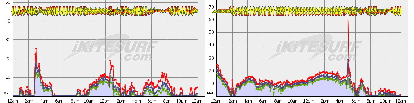
Some of the challenges of summer weather in South Florida (June 8 & Friday the 13th, 2014, Dania Beach, FL)
Kitesurfers have been banging their heads against this phenomena since the sport started in South Florida. It is an institution,
reviled but a regular event with varying durations each year. We even shared ideas on how to cope on the forum, such as: "Summer Florida Kiter Survival Guide"
http://www.fksa.org/showthread.php?t=500
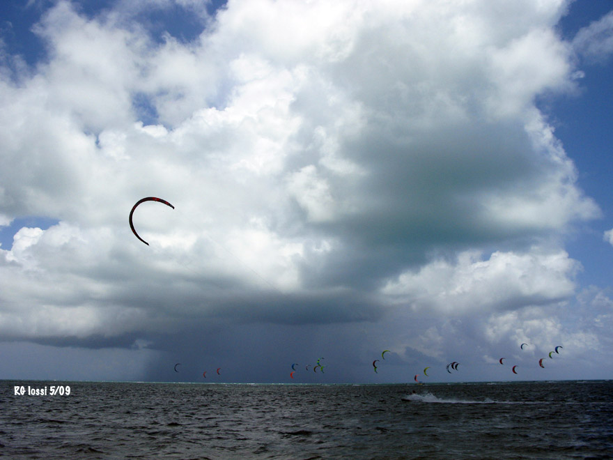
Fragments of a tropical system visit Miami
We talked about chronic calms along with the serious hazards of summer weather patterns. Things like violent thunderstorms related
to tropical systems, dangerous popup squalls in the afternoon off the Everglades and static discharge off lines followed by lightening
here. And, most importantly about planning to get out of town on wind destination trips to try to preserve mind and soul in the dry months.
The regular loss of wind was that persistent and impacting on our wind prospects. Some of us learned to accept it, after many years of
trying to deal with it. I never really asked myself, "why" does this happen, why does the wind turn off in late May to early June and
stay that way for several weeks while turning back on for fitful short durations in varying degrees until August even out to October?
Today's lighter wind kites and boards will make a serious dent on lost time in the low wind months, thankfully, but they will likely
descend yet again in not too many more weeks here.
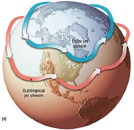
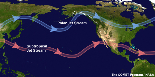
Shea Gibson, meteorologist with Weatherflow/iKitesurf and an avid kiter provides an explanation for WHY our wind goes away
in South Florida and the east coast with such consistency while the wind season may turn on for much of the rest of the country. Things
like polar jets recede northward taking the more powerful fronts of the cooler months with them while blocking patterns do just that,
easing flow over the east coast and a good deal more. Thanks Shea! and with that the first part of his article on wind lost, then
found, eventually ...
"What happens in Florida, stays in Florida.
Posted on April 28, 2015 by WeatherFlow Forecaster
By WeatherFlow meteorologist Shea Gibson.
Besides being a great place to visit with more miles of beach than any other state in the US (663 miles to be exact), the title above actually eludes to a stagnant weather pattern that develops during the hotter months along the east coast of Florida. During the spring, the subtropical jet (a belt of upper level warmer air) starts to lift up into the United States to help turn the season. Bermuda High’s start to briefly park out in the Atlantic and place what is called a “ridge axis” over the northern to central FL east coast and keeps wind speeds lowered along the SE/ESE flows. As we get into the summer months, this pattern becomes more fixed (also known as a blocking pattern). For eastern FL, many times we see haze and fogging , which are signs of stable air…instability is needed for stronger winds to develop. Other times we see cloud contamination overrunning the land and sea interface with nagging rains/showers throughout the day, which further squashes winds.
Here are examples of the subtropical jet stream (with the winter-time polar jet stream receding to the north).
The first thing we need to look at for evidence is that during these hotter months, the Gulf of Mexico tends to hold its own blocking pattern as High pressure nestles up into the northeast Gulf and parks for days at a time – and sometimes up to a week or longer. This is partly due to the curvature of land and heat fluxes/dryer air in that pocket of coastline. It is also partially due to the subtropical jet stream pulling up from the south and stretching across the northern part of the state (sometimes stretching frontal boundaries horizontally as they drop down along the northern Gulf). These High pressures also tend to bring a NW/W element northwards all the way up into the Carolinas to add to their nocturnal land breezing – and in many cases, they help provide good mid/upper level westerly convergences to fire off storming that helps bring GA/SC/NC Sea Breezes up in speeds…..with an occasional secondary lobe of Southern Appalachian High pressure able to push that flow even higher. Meanwhile, back on the east coast of Florida, there is a struggle as winds clocking around the NE Gulf High are keeping the builds down to central and south Florida while pushing a NW/N synoptic flow down the coast. At night during radiational cooling, this is increased…and also cross-cuts the Sea Breezes during the day. This great for the Gulf side as their Sea Breezes build off the onshore NW flows, but not so good for the Atlantic side of the state.
Here is a typical pattern where we see the Northeast Gulf High firmly in place. Notice this is at 0:00 (12:00am) for the night time values to show NW flow to east FL, W/WNW directions to GA/SC and W/WSW to Southeast North Carolina. This represents a solid summer nocturnal land breeze setup along SE Regional coastline.

"
SECONDLY ... (please continue reading this excellent article at: http://blog.weatherflow.com/what-hap...s-in-florida/)
.