Here is some more recent information on now Hurricane Sandy. They are saying it might build in strength to above Cat. I strength over the Bahamas. Interests in impacted areas need to monitor this system closely.
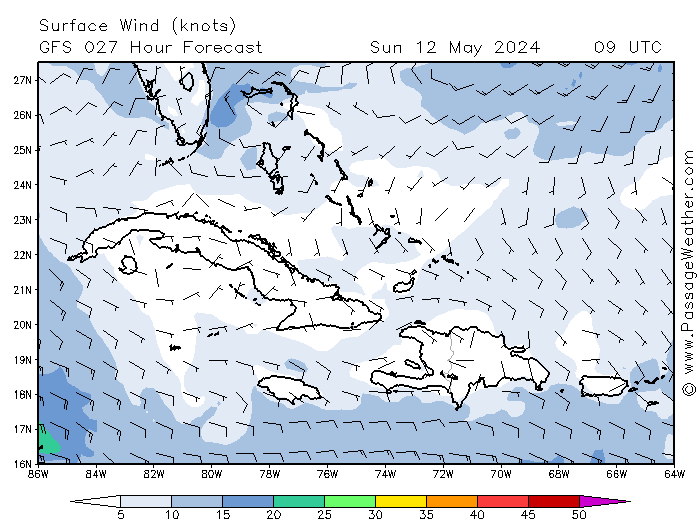
From Passageweather.com
Here is one model forecast for the wind field and organization of Sandy at 4 pm local time tomorrow, Thursday.
Looking at the current satellite imagery it seems reasonable that we may have some serious squalls at points in Florida from feeder bands as Sandy moves north.
 http://www.wunderground.com/data/
A look at the basin satellite imagery
 http://www.wunderground.com/
A closer look at Florida, some feeder bands are already sliding over Florida Tuesday afternoon.
 http://www.nhc.noaa.gov
Be sure to monitor http://www.nhc.noaa.gov/ and http://fksa.org/showthread.php?t=1609 as this system passes through to try to avoid nasty surprises.
Here is the NWS forecast for Palm Beach County. This will change in the coming days how much in what way is uncertain at this time.
"Coastal waters from Jupiter Inlet to Deerfield Beach FL out 20 NM
Rest Of Tonight: East northeast winds 16 to 21 knots along the coast to east northeast 21 to 26 knots in the gulf stream. Seas 8 to 10 feet with occasional seas up to 13 feet. Dominant period 7 seconds. Intracoastal waters rough in exposed areas. Chance of showers.
Thursday: Northeast winds 24 to 29 knots with gusts to around 40 knots along the coast to northeast 25 to 30 knots with gusts to around 40 knots in the gulf stream. Seas 10 to 12 feet with occasional seas up to 15 feet. Dominant period 8 seconds. Northeast swell 3 feet increasing to east northeast 3 to 4 feet in the afternoon. Intracoastal waters very rough in exposed areas. Chance of showers. Slight chance of thunderstorms in the afternoon.
Thursday Night: Along the coast...north northeast winds 25 to 30 knots with gusts to around 40 knots becoming north 32 to 37 knots with gusts to around 50 knots...seas 14 to 17 feet with occasional seas up to 20 feet. In the gulf stream...north northeast winds 31 to 36 knots with gusts to around 50 knots becoming north 37 to 42 knots with gusts to around 60 knots... Seas 18 to 22 feet with occasional seas up to 25 feet. Seas 11 to 13 feet with occasional seas up to 17 feet in the evening. Dominant period 10 seconds. Intracoastal waters extremely rough. Showers likely and chance of thunderstorms.
Friday: North northwest winds 37 to 42 knots with gusts to around 60 knots along the coast to northwest 45 to 50 knots with gusts to around 65 knots in the gulf stream. Along the coast... Seas over 20 feet with occasional seas up to 27 feet building to over 20 feet with occasional seas up to 31 feet in the afternoon. In the gulf stream...seas over 20 feet with occasional seas up to 38 feet building to over 20 feet with occasional seas up to 45 feet in the afternoon. Dominant period 11 seconds. Intracoastal waters extremely rough in exposed areas. Showers likely and chance of thunderstorms.
Friday Night: Along the coast...northwest winds 33 to 38 knots with gusts to around 55 knots becoming west northwest 25 to 30 knots with gusts to around 40 knots...seas over 20 feet with occasional seas up to 29 feet subsiding to 16 to 20 feet with occasional seas up to 23 feet. In the gulf stream...west northwest winds 39 to 44 knots with gusts to around 60 knots... Seas over 20 feet with occasional seas up to 41 feet subsiding to over 20 feet with occasional seas up to 36 feet. Intracoastal waters extremely rough in exposed areas. Chance of showers and slight chance of thunderstorms.
Saturday: West northwest winds 25 to 30 knots along the coast to west northwest 30 to 35 knots in the gulf stream. Gusts up to 50 knots. Along the coast...seas 12 to 14 feet with occasional seas up to 18 feet. In the gulf stream...seas over 20 feet with occasional seas up to 29 feet subsiding to 18 to 22 feet with occasional seas up to 25 feet in the afternoon. Intracoastal waters rough in exposed areas. Slight chance of showers.
Saturday Night: Northwest winds 18 to 23 knots along the coast to northwest 24 to 29 knots with gusts to around 40 knots in the gulf stream. Along the coast...seas 11 to 13 feet with occasional seas up to 17 feet. In the gulf stream...seas 17 to 21 feet with occasional seas up to 24 feet subsiding to 14 to 17 feet with occasional seas up to 20 feet. North swell 5 to 8 feet. Intracoastal waters choppy in exposed areas. "
http://www.srh.noaa.gov/mfl/
Speaking of the Bahamas, it doesn't look good over there at all from the forecast, much less for kiting per Barometer Bob in the Abacos. Bet there will be a ton of squalls as well as high sustained winds the rest of the time with the storm passage.
"*Marine Forecast For Abacos ~ Updated ~ Wednesday, October 24, 2012 6:00:02 PM
Wednesday Night
Overcast with thunderstorms, then a chance of rain after midnight. Low of 73F. Windy. Winds from the ENE at 30 to 35 mph. Chance of rain 80% with rainfall amounts near 0.3 in. possible.
Thursday
Overcast with rain. High of 81F. Winds from the NE at 45 to 60 mph. Chance of rain 100% with rainfall amounts near 2.0 in. possible.
Thursday Night
Overcast with rain. Fog overnight. Low of 72F. Winds from the NE at 20 to 65 mph. Chance of rain 100% with rainfall amounts near 3.3 in. possible.
Friday
Overcast with a chance of rain, then a chance of a thunderstorm and rain in the afternoon. Fog early. High of 82F with a heat index of 95F. Windy. Winds from the SW at 5 to 45 mph. Chance of rain 50% with rainfall amounts near 0.2 in. possible.
Friday Night
Overcast with a chance of rain in the evening, then partly cloudy with a chance of rain. Low of 75F. Winds from the WNW at 40 to 55 mph. Chance of rain 50%.
Saturday
Overcast with a chance of a thunderstorm and rain. High of 81F. Winds from the WNW at 40 to 45 mph. Chance of rain 60% with rainfall amounts near 0.2 in. possible.
Saturday Night
Partly cloudy with a chance of a thunderstorm and rain, then a chance of rain after midnight. Low of 72F. Winds from the NW at 30 to 45 mph. Chance of rain 50%.
"
http://barometerbob.org
From the forecast there will be times when conditions won't be kiteable due to excessively strong gusty winds particularly on Friday and at times tomorrow as well in Southeast Florida.
Kite, if you choose to go at all, responsibly within your abilities in these advanced conditions, experience and gear limits as always. Don't have a small enough kite, solid past experience in similar conditions or if squalls move in, don't kite.
.