 |
|
#21
|
||||
|
||||
|
How did it go up there John? How about other folks up the coast, some good swells come in? It was flat as a pond off the SE coast on Sunday. That is except for these mysterious sets that would move in out of the blue every once in a while. Bill swells likely enough, way to the south of the system too.
__________________
FKA, Inc. transcribed by: Rick Iossi |
|
#22
|
||||
|
||||
|
I had quietly put this away around the first of November. Impressions can sometimes be wrong, regardless of how much you would like them to be true. So, back up it goes for a while longer. Fingers crossed and best of luck to the folks in the Gulf dealing with Ida.
__________________
FKA, Inc. transcribed by: Rick Iossi |
|
#23
|
||||
|
||||
|
Just added some new resources to the top of the list of weather sites. They include some powerful new GIS/Sat. Map interactive pages. Check it out!
http://fksa.org/showthread.php?t=1609
__________________
FKA, Inc. transcribed by: Rick Iossi |
|
#24
|
||||
|
||||
|
Looking wet and breezy for Friday and Saturday in the SE. Hope this one doesn't amount to much.
 http://www.nhc.noaa.gov/graphics_at3...large#contents "Hazards affecting land ---------------------- wind...winds near tropical storm force are already affecting portions of the southeastern Bahamas. Tropical storm conditions will gradually spread over the central and northwestern Bahamas tonight and Friday. Weather conditions will begin to deteriorate on the Florida coast and Florida Keys within the warning area on Friday. Rainfall...the depression is expected to produce total rain accumulations of of 2 to 4 inches over South Florida...with possible isolated maximum amounts of 5 to 6 inches. Rainfall amounts of 3 to 5 inches are expected over the central and northwest Bahamas...with possible isolated amounts of 5 to 7 inches. Storm surge...storm surge will raise water levels by as much as 1 to 2 feet above ground level over portions of the Bahamas and the Florida Keys." http://www.wunderground.com/tropical...03.public.html
__________________
FKA, Inc. transcribed by: Rick Iossi |
|
#25
|
|||
|
|||
|
|
|
#26
|
||||
|
||||
|
I've added animated, color enhanced satellite image panels extending from Africa over to around Florida to the top of this thread.
__________________
FKA, Inc. transcribed by: Rick Iossi |
|
#27
|
||||
|
||||
|
Hurricane season is on again, time to bring this back to the top. Prepare as always and hope for a favorable season.
__________________
FKA, Inc. transcribed by: Rick Iossi |
|
#28
|
||||
|
||||
|
Hey Rick,
This is a great website for tracking the tropics, the person "Jay" that designed this website put dozens of radar, satellite, vapor loop, sea surface temp, wind direction/speed maps and links to all the important websites, NOAA, Wunderground, Weather Channel, Accuweather, etc, etc all on one webpage, It's a great one stop shop, for all your mapping needs! I've got it bookmarked on my laptop and Iphone. http://www.tropicwx.com/ JP
__________________
the sky is not the limit, it is my playground |
|
#29
|
||||
|
||||
|
Thats a nice one JP, thanks for posting it. It looks like TS Brett may be pulled off to the NE to be lost in the Atlantic, we can hope. I started putting this page up in 2004 before there were many other sites with collections of a wide variety of imagery. Today there are quite a few good ones. One of the more useful things in the current collection on this site are the various sector animated Wunderunderground color satellite images. They can really help with a rapid lay evaluation of changes in organization and direction of travel. Here's to a favorable tropical weather season.
__________________
FKA, Inc. transcribed by: Rick Iossi |
|
#30
|
||||
|
||||
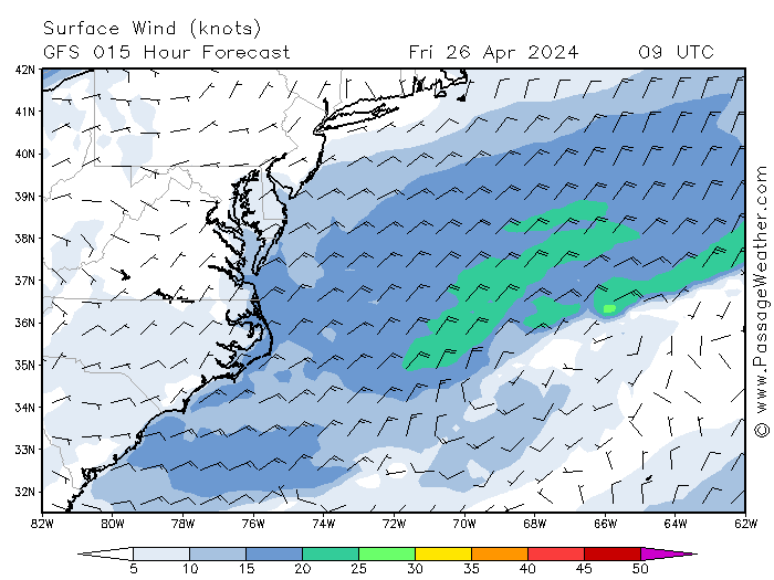
 http://www.nhc.noaa.gov/graphics_at4...large#contents The eye of tIrene is moving north northeast through the outebanks of North Carolina at 15 mph through the coastline of numerous states towards New England as a Cat. I storm with sustained 85 mph winds gusting higher. Hurricane and tropical force winds extend outward from the center 90 and 260 miles respectively per the NHC. http://www.nhc.noaa.gov/text/refresh.../271448.shtml? http://www.wunderground.com/ http://www.wunderground.com/tropical/ The NHC cone is in part derived from the evaluation of several models. The Weatherunderground cone and track map shows similar information to the NHC map but may be more readable. This shows the predicted hurricane core locations and strengths through Monday. The hurricane is forecast to substantially impact eastern parts of North Carolina up into New England between Saturday and Monday.  http://passageweather.com/index.htm?...es/mappage.htm Two models, the GFE and NAM are depicted along with wind fields in this figure. If you hit next or animate at the link above, it will show you the predicted tract. NOTE: the maximum wind this map shows is 50 kts even though winds may go much higher both in sustained winds, squalls, tornadoes, etc.As always, these models and actual storm movements will change through time. Still, if you live in predicted effected areas I would take appropriate steps per official instructions in your area to prepare and hope for the best as we do in Florida. Good luck and take care.
__________________
FKA, Inc. transcribed by: Rick Iossi |
 |
|
|